mapbox实现计算两个点之间的距离
 六月初
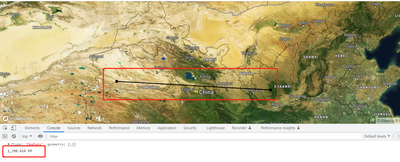
六月初mapbox实现标记两个点,获取两个点之间的直线距离为多少。
效果如图:
代码详情:
<!DOCTYPE html>
<html>
<head>
    <meta charset='utf-8' />
    <title>显示卫星地图</title>
    <meta name='viewport' content='initial-scale=1,maximum-scale=1,user-scalable=no' />
   <script src="https://api.tiles.mapbox.com/mapbox-gl-js/v2.9.2/mapbox-gl.js"></script>
   <link
     href="https://api.tiles.mapbox.com/mapbox-gl-js/v2.9.2/mapbox-gl.css"
     rel="stylesheet"
   />
    <script src="https://unpkg.com/@turf/turf@6/turf.min.js"></script>
	<style>
        body { margin:0; padding:0; }
        #map { position:absolute; top:0; bottom:0; width:100%; }
    </style>
</head>
<body>
<div id='map'></div>
<script>
	mapboxgl.accessToken = 'pk.eyJ1Ijoic2l4YmxvZyIsImEiOiJjbDYxdjNxbTcwMzZ3M2ZwNzkzOWJqNTI5In0.o6rf1thO5EbTqa5gXOJKYA';
	var map = new mapboxgl.Map({
		container: 'map',
		zoom: 4.5,
		center: [105.000, 38.000],
		style: 'mapbox://styles/mapbox/satellite-streets-v11'
	});

	const measureList = {
		'type': 'FeatureCollection',
		'features': []
	};
	const measureLinestring = {
		'type': 'Feature',
		'geometry': {
			'type': 'LineString',
			'coordinates': []
		}
	};
	map.on('load', () => {
		map.addSource('measureSource', {
			'type': 'geojson',
			'data': measureList
		});
		map.addLayer({
			id: 'measure-points',
			type: 'circle',
			source: 'measureSource',
			paint: {
				'circle-radius': 5,
				'circle-color': '#000'
			},
			filter: ['in', '$type', 'Point']
		});
		map.addLayer({
			id: 'measure-lines',
			type: 'line',
			source: 'measureSource',
			layout: {
				'line-cap': 'round',
				'line-join': 'round'
			},
			paint: {
				'line-color': '#000',
				'line-width': 2.5
			},
			filter: ['in', '$type', 'LineString']
		});
	})

	map.on('click', (e) => {
		const features = map.queryRenderedFeatures(e.point, {
			layers: ['measure-points']
		});

		// Remove the linestring from the group
		// so we can redraw it based on the points collection.
		if (measureList.features.length > 1) measureList.features.pop();

		// Clear the distance container to populate it with a new value.
		// distanceContainer.innerHTML = '';

		// If a feature was clicked, remove it from the map.
		if (features.length) {
			const id = features[0].properties.id;
			measureList.features = measureList.features.filter(
				(point) => point.properties.id !== id
			);
		} else {
			const point = {
				'type': 'Feature',
				'geometry': {
					'type': 'Point',
					'coordinates': [e.lngLat.lng, e.lngLat.lat]
				},
				'properties': {
					'id': '自定义携带参数'
				}
			};

			measureList.features.push(point);
		}

		if (measureList.features.length > 1) {
			measureLinestring.geometry.coordinates = measureList.features.map(
				(point) => point.geometry.coordinates
			);

			if (measureList.features.length > 2) {
				measureList.features.length = 0
				map.getSource('measureSource').setData(measureList);
				return false;
			}
			measureList.features.push(measureLinestring);
			console.log(measureLinestring)
			// Populate the distanceContainer with total distance
			// const value = document.createElement('pre');
			const distance = turf.length(measureLinestring);
			// value.textContent = `Total distance: ${distance.toLocaleString()}km`;
			// distanceContainer.appendChild(value);
			console.log(distance.toLocaleString() + ' KM')
		}

		map.getSource('measureSource').setData(measureList);
	})
</script>
</body>
</html>
代码说明:官方案例中,实现的连续点之间的距离。本文在此基础上进行处理,只会获取两个点之间的直线距离。前两次点击会标记点和计算距离,第三次点击会清空现有点和距离,进行从新的描点和计算。
 六月初字帖坊小程序
你想要的字帖模板及工具,这里都有!
六月初字帖坊小程序
你想要的字帖模板及工具,这里都有!
919篇文章
4737人已阅读